

Yogyakarta, 1 October 2026 – The Master’s Program in Environmental Science at the Graduate School of Universitas Gadjah Mada (UGM) held a guest lecture for the Natural Resources and Environmental Management (PSDAL) course on Thursday (1/10). The lecture was conducted online via Zoom and featured Prof. Josaphat Tetuko Sri Sumantyo, Ph.D. from Chiba University, Japan, who delivered a presentation on remote sensing using synthetic aperture radar (SAR). More than 100 participants from various institutions attended the session online.
Prof. Josaphat Tetuko Sri Sumantyo, Ph.D. delivering his presentation during the online guest lecture
In his presentation, Prof. Josaphat explained the differences between optical sensors and SAR. Optical sensors rely on sunlight, while SAR is an active sensor that transmits microwave signals from satellites, aircraft, or drones and processes the reflected signals into images. SAR can therefore penetrate clouds and operate at night, making it particularly useful for monitoring tropical regions such as Indonesia. Through polarization analysis, SAR can also provide information about the physical characteristics of objects, such as the inclination of tree trunks.
He introduced circularly polarized synthetic aperture radar (CP-SAR), a technology developed by his team at Chiba University, including its self-designed antenna. A CP-SAR flight test was conducted at Adisutjipto Air Base in Yogyakarta between August and September 2017. The observations demonstrated that the imagery remained clear under cloudy conditions, when optical cameras were obstructed by clouds.
Participants were also introduced to various applications of SAR in disaster management and environmental monitoring, including:
- monitoring land subsidence and sedimentation in the coastal areas of Jakarta;
- detecting land uplift following the Noto earthquake in Japan on 1 January 2024;
- landslide mapping in Cameron Highlands, Malaysia; and
- detecting volcanic deformation anomalies, which contributed to his team winning the IEEE GRSS 2026 Data Fusion Contest in Washington, D.C., on 9 August 2026.
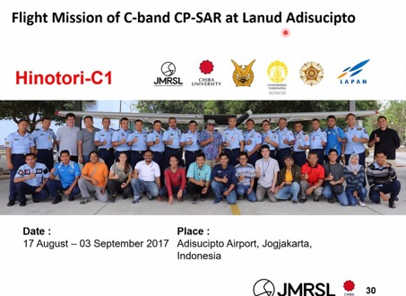
CP-SAR C-band Hinotori-C1 flight mission at Adisutjipto Air Base, Yogyakarta (2017) |
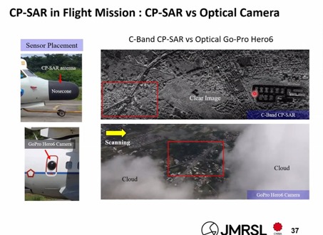
CP-SAR imagery remained clear under cloudy conditions compared with optical camera imagery |
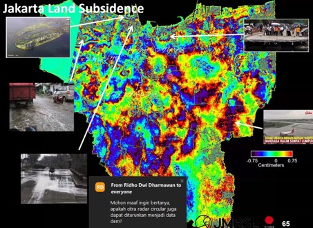
Land subsidence in Jakarta based on SAR data processing |
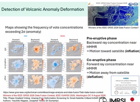
Volcanic deformation anomaly detection, which won the IEEE GRSS 2026 Data Fusion Contest |
Source: Presentation materials by Prof. Josaphat Tetuko Sri Sumantyo, Ph.D.
Prof. Josaphat emphasized that forest and land fires, for example, can be predicted before they occur, allowing preventive measures to be taken at an earlier stage.
The question-and-answer session was highly interactive. Participants asked about the potential of SAR for detecting oil spills, the need for terrain correction using digital elevation models (DEMs) when detecting burned areas in mountainous regions, recent developments in InSAR and NISAR satellite technology, the use of artificial intelligence (AI) for radar imagery, and how to select the appropriate imaging band for a particular research object. Prof. Josaphat emphasized that researchers should first determine their research objectives and objects before selecting the most appropriate imagery and frequency band.
The guest lecture also contributed directly to the achievement of several Sustainable Development Goals (SDGs), including:
- SDG 4: Quality Education, by strengthening academic capacity and facilitating access to cutting-edge knowledge in remote sensing for students and academics;
- SDG 11: Sustainable Cities and Communities, through the application of SAR technology to monitor land subsidence in urban coastal areas and support disaster risk mitigation;
- SDG 13: Climate Action, through the use of remote sensing for early warning systems, forest and land-fire prediction, and real-time monitoring of environmental dynamics;
- SDG 15: Life on Land, through the mapping of land-cover changes, landslide risks, and the monitoring of terrestrial ecosystem conservation; and
- SDG 17: Partnerships for the Goals, through international research collaboration and academic networking between Universitas Gadjah Mada and Chiba University, Japan.
At the end of the lecture, Prof. Josaphat encouraged students to write books as works that would continue to provide value over time and to regard awards as a bonus. He also encouraged Indonesian researchers to strengthen collaboration and foster mutual respect.
“We should not have the mindset of catching up, because we are not behind. The greatness of a nation cannot be inherited; it must be built from now.”
Prof. Josaphat Tetuko Sri Sumantyo, Ph.D.
Through this guest lecture, students of the UGM Master’s Program in Environmental Science gained insights into the application of remote sensing technology for natural resource management and disaster mitigation.