
Students from the Master of Environmental Science program at Universitas Gadjah Mada (UGM) conducted a field study on coastal resilience in Pemalang Regency from 14–17 July 2025. Portions of Pemalang along the northern coast of Java have experienced rapid development but face significant threats from climate change. Unlike other northern coastal areas such as Semarang, Demak, or Jakarta, which have received public attention, Pemalang has not yet become a priority area for mitigation efforts, despite the significant impacts of coastal hazards already felt by local communities.


(Documentation of Activities)
From a physical perspective, the study employed the Coastal Hazard Wheel (CHW), a standardized classification system developed by Roshendal Applequist in collaboration with UNEP, to assess hazards affecting coastal areas due to climate change and human activities. The research covered Pemalang’s coastline bordering the Java Northern Coast, including the districts of Ulujami, Petarukan, Taman, and Pemalang, spanning a total coastline of 45.16 km. Six biogeophysical parameters were the focus of analysis: landform or geological layout, waves, tides, presence of flora (mangroves or other vegetation), sediment balance, and storm climate. The primary objective was to assess multi-hazard risks in Pemalang’s coastal areas and formulate recommendations for effective management.
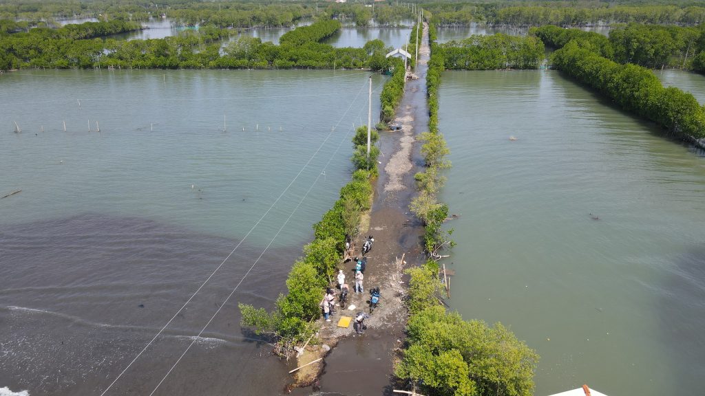
Preliminary results indicate concerning conditions along Pemalang’s coast. Analysis shows moderate to very high threats of ecosystem disruption and inundation, low to high erosion hazards, and moderate to high risks of seawater intrusion and tidal flooding. This is supported by observations from certain coastal areas, including Pantai Kramatsari Blendung, Pantai Ketapang, Pantai Kertosari, and Pantai Kaliprau, which have experienced shoreline loss due to tidal flooding in May 2025. Data from the Pemalang Regency Disaster Management Agency (BPBD) indicate eight districts classified as flood-prone, four of which are coastal, with a total flood-prone area of 27,387.34 hectares. The tidal flooding at the end of May 2025 severely affected Kertosari Village, with 50% of its area submerged, consisting of 30% agricultural/fishery land and 20% residential areas, while Blendung Village experienced complete inundation, according to Mr. Waryono, advisor for the Land Fisheries Cooperative.

(Documentation of Activities)
To ensure comprehensive results, the research team coordinated with multiple local government agencies, including BPBD, Environmental Agency, Fisheries Department, Tourism, Youth and Sports Department, BAPPEDA, Public Works and Spatial Planning Department, and the Provincial Forestry Office V. Because the management of some coastal and marine areas falls under provincial authority, the team also collaborated with the Public Works and Water Resources Department of Central Java Province. The Pemalang Regency government provided full support, supplying data, information, and documents for analysis, including disaster records, spatial planning documents, risk assessments, strategic plans, and other resources relevant to coastal management.
This field study aligns with several Sustainable Development Goals (SDGs), notably SDG 13 (Climate Action) by analyzing climate change impacts on coastal areas, SDG 14 (Life Below Water) in the context of protecting marine and coastal ecosystems, and SDG 15 (Life on Land) through conservation of terrestrial ecosystems in coastal zones. The research is expected to serve as an early warning for local communities to initiate mitigation and adaptation measures and as a basis for policy and program development by local and national authorities. As noted by Mr. Waryono, the advisor of the Land Fisheries Cooperative in Blendung Village, the findings are hoped to reach government officials to enhance attention to Pemalang’s coastal conditions and support community efforts to reduce disaster impacts.
Penulis: Tim KKL